Flash Flood Warnings Cover Los Angeles as Pacific Storm Sweeps Southern California
Los Angeles Flood Threat Builds as El Niño Storm Sweeps South
bloomberg.com· 2d
Storm brings heavy rain, flood threat to Southern California
newsnationnow.com· 2d
California Storm Sweeps South, Prompting Some Evacuation Warnings in L.A.
nytimes.com· 2d
San Francisco break century-old record for rainfall
youtube.com· 3d
L.A. County issues evacuation warnings as storm nears; snow, flooding expected
latimes.com· 3d
Storm Brings Torrential Rain and Floods to the San Francisco Bay Area
Bay Area storm live updates: I-580 westbound blocked; S.F. ‘poop water’ flooding
sfchronicle.com· 3d
California Faces Flood Risks and Heavy Snow From Pacific Storm
Another Storm Is Bearing Down on California
Rain, snow coming to drought regions. It could be a preview of a wild winter.
washingtonpost.com· 5d
Photos: California residents gather to watch massive El Nino-fuelled waves
aljazeera.com· 5d
Huge waves pummel the California coast, forcing the closure of iconic piers
apnews.com· 6d
The Surf’s Way, Way Up as Huge Waves Pound the California Coast
California Could Face 50-Foot Waves as Storms Slam Its Coast
Biggest waves in years to slam California coast — including San Francisco
A Pacific storm fueled by El Niño swept south through California in mid-November 2026, flooding the Bay Area before reaching Los Angeles.
Los Angeles County issued evacuation warnings for residents near recent fire burn scars, in effect from 18 to 20 November.
Flash flood warnings covered parts of Los Angeles County on 19 November, with rain forecast at up to an inch per 30 minutes through noon.
San Francisco recorded 2.28 inches of rain on 18 November, a century-old daily record, amid flooding, long flight delays and power outages.
Forecasters expected the storm to weaken by Thursday afternoon, with rain tapering by evening and cooler, drier weather on Friday.
Forecasters on 10 November predicted the biggest waves in years along the Northern California coast, with breaking waves of 30 to 40 feet possible on 13 and 14 November.
Joe Merchant, a meteorologist at the National Weather Service, said the waves could be 'pretty problematic', and officials urged people to avoid the ocean and even the beach.
A string of storms beginning around 12 November was forecast to bring California its first prolonged stretch of widespread rain, wind, snow and big waves of the season.
Brian Garcia, a meteorologist at the National Weather Service office serving the San Francisco Bay Area, advised people to watch webcams of the beach instead of going near the water.
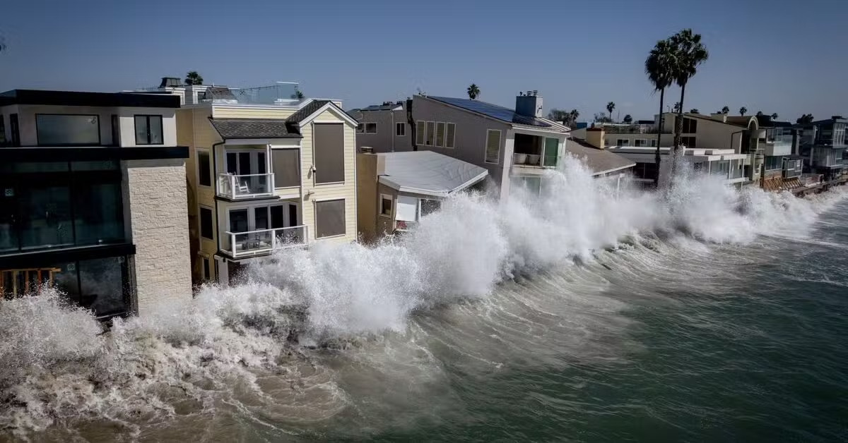
The biggest waves since December 2024 pounded the California coast on 14 November, with about 270 homes in Santa Cruz County under evacuation warnings.
Jason Hoppin, a spokesman for Santa Cruz County, said, 'We're seeing some minor flooding, but our infrastructure is holding up so far.'
Roger Gass, a meteorologist at the National Weather Service office in Monterey, said, 'No selfie of the crashing waves is worth losing your life.'
Waves above 50 feet were recorded in San Mateo County on 14 November, and piers in Ventura, Manhattan Beach, Huntington Beach and San Diego's Pacific Beach were closed that weekend.
The Santa Cruz County Sheriff's Office issued an evacuation warning near the coastal town of Capitola, which took the brunt of the surf.
The National Weather Service issued a high surf advisory on 15 November forecasting waves breaking as high as 35 feet along Pacific Coast beaches.
The National Weather Service warned, 'Stay out of the water, stay off rocks and jetties, and never turn your back on the ocean.'
Climate scientist Daniel Swain said in a social media post that 'the odds of an unusually wet, and perhaps exceptionally wet, second half of November continue to rise in California'.
Rare dual waterspouts were spotted on San Francisco Bay late on the morning of 16 November.
Forecasters on 17 November predicted a storm-after-storm pattern through Thanksgiving, with 2 to 5 inches of coastal rain and 1 to 3 feet of snow in the Sierra Nevada.
El Niño had pushed ocean levels along the entire West Coast higher than normal, heightening the coastal flooding threat.
Chad Hecht, a meteorologist at the Center for Western Weather and Water Extremes, forecast that the storm would likely be one of the better snowpack contributors so far this year.
Los Angeles County's public works department said the county issued a phase 1 warning to recently burned areas including the Hollywood Hills and Malibu about mud and debris flows.
Downtown San Francisco recorded 2.28 inches of rain by 2:40 p.m. on 18 November, breaking the 18 November daily record of 2.24 inches set in 1918.
Bay Area flooding on 18 November blocked westbound Interstate 580, delayed flights into San Francisco International Airport by up to 186 minutes and cut power to about 45,900 PG&E customers.
Waymo suspended its autonomous ride-hail service in the Bay Area on the morning of 18 November, citing the weather.
Runoff overwhelmed part of San Francisco's sewage system on 18 November, sending a geyser about 15 feet up near Ocean Beach.
Residents near the Contra Costa County fairgrounds in Antioch were warned to prepare to evacuate amid flooding on 18 November.
San Francisco Mayor Daniel Lurie said the city expected flooding to return to many of the same areas when the next storms came, and urged residents to keep cars away from flooded streets and prepare.
Mary Ellen Carroll, San Francisco's emergency management director, said the city fielded a record number of emergency calls on the morning of 18 November but dispatched ambulances and other vehicles without incident.
Nancy Crowley, press secretary for the San Francisco Public Utilities Commission, said the city's combined sewer stormwater system can become overwhelmed during intense storms and that most of the overflow is rainwater.
Highway 1 was closed along the Big Sur coast on 18 November because of severe mudslide risks over land recently burned by wildfire.
Water poured through the ceiling of the Moscone Center in San Francisco during the Microsoft Ignite conference on 18 November, and one floor was evacuated.
Los Angeles Mayor Karen Bass said in a statement, 'Heavy rain could cause flooded roadways, downed trees, and mud and debris flows that Angelenos need to take seriously.'
Waymo said it planned to resume its self-driving taxi service in the Bay Area once road and weather conditions made it safe.
Los Angeles County issued evacuation warnings, in effect from 6 p.m. on 18 November to 8 a.m. on 20 November, for residents near recent fire burn scars.
The National Weather Service issued a flood watch for Santa Barbara, San Luis Obispo, Ventura and Los Angeles counties, except the Antelope Valley.
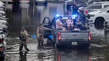
California activated its State Operations Center and prepositioned fire personnel and equipment, including engines and swift water rescue teams, near at-risk communities.
Liz Vazquez, a public information officer for Los Angeles County Public Works, said in an email that the agency was preparing crews and equipment to respond to the storm.
Colleen Park, a public information officer for California Department of Transportation District 7, said crews were clearing drainage systems, reinforcing slopes, staging equipment and staffing 24-hour maintenance crews during the storm.
The Los Angeles County Office of Emergency Services encouraged all residents to stay away from flood control channels, catch basins, canyons and natural waterways vulnerable to flooding.
A storm swept into Southern California on 19 November, bringing heavy rain, thunderstorms and winds, and part of Los Angeles County was placed under a flash flood warning until noon.
Officials in Los Angeles County and Ventura County told some residents on 19 November to be prepared to evacuate.
Rainfall rates topped an inch an hour early on 19 November, prompting multiple flash flood warnings in San Luis Obispo and Santa Barbara counties.
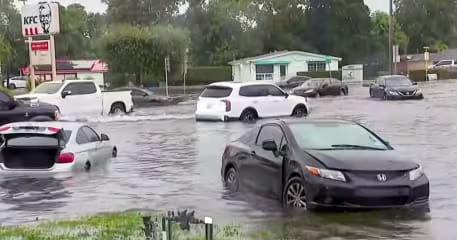
By mid-morning on 19 November streets across Los Angeles were flooded, and police tape blocked a waterlogged stretch of Rossmore Avenue in Hancock Park.
Flood watches covered most of Los Angeles County, excluding the Antelope Valley, through Thursday afternoon, 19 November.
The National Weather Service forecast 1 to 3 inches of rain, up to 5 on coastal slopes, with rates above an inch per hour in some areas.
The National Weather Service warned of significant road flooding, mudslides and debris flows near recent burn scars, and a chance of weak tornadoes in the Los Angeles Basin.
On 19 November the National Weather Service warned of torrential rain through noon, falling at rates of up to 1 inch per 30 minutes.
Flood warnings on 19 November covered Malibu, Beverly Hills, downtown Los Angeles, the San Fernando Valley, Altadena and the Eaton burn scar.